QGIS and RS Gis Tutorial : What is Remote Sensing ? The Definitive Guide in one minutes RS GIS
What is remote sensing and what is it used for?
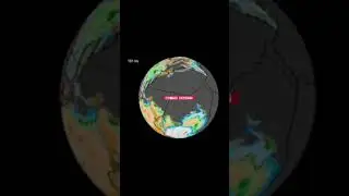
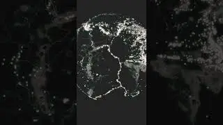
Remote sensing is the process of detecting and monitoring the physical characteristics of an area by measuring its reflected and emitted radiation at a distance (typically from satellite or aircraft). Special cameras collect remotely sensed images, which help researchers "sense" things about the Earth. Some examples are:
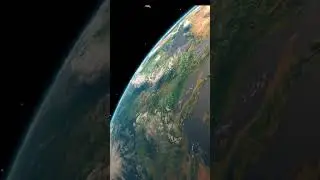
Cameras on satellites and airplanes take images of large areas on the Earth's surface, allowing us to see much more than we can see when standing on the ground.
Sonar systems on ships can be used to create images of the ocean floor without needing to travel to the bottom of the ocean.
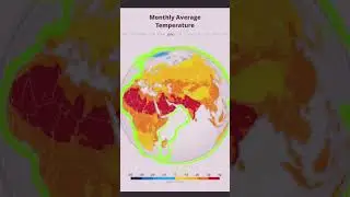
Cameras on satellites can be used to make images of temperature changes in the oceans.
Some specific uses of remotely sensed images of the Earth include:
Large forest fires can be mapped from space, allowing rangers to see a much larger area than from the ground.
Tracking clouds to help predict the weather or watching erupting volcanoes, and help watching for dust storms.
Tracking the growth of a city and changes in farmland or forests over several years or decades.
Discovery and mapping of the rugged topography of the ocean floor (e.g., huge mountain ranges, deep canyons, and the “magnetic striping” on the ocean floor).
.......
What is Remote Sensing?
Remote sensing is the science of obtaining the physical properties of an area without being there. It allows users to capture, visualize, and analyze objects and features on the Earth's surface. By collecting imagery, we can classify it into land cover and other types of analyses.
.....................
¿Qué es la teledetección?
La teledetección es la ciencia de obtener las propiedades físicas de un área sin estar allí. Permite a los usuarios capturar, visualizar y analizar objetos y características en la superficie de la Tierra. Al recopilar imágenes, podemos clasificarlas en cobertura terrestre y otros tipos de análisis.
.......................
سنجش از دور چیست؟
سنجش از دور علم به دست آوردن خواص فیزیکی یک منطقه بدون وجود آن است. این به کاربران اجازه می دهد تا اشیا و ویژگی های روی سطح زمین را ضبط، تجسم و تجزیه و تحلیل کنند. با جمعآوری تصاویر، میتوان آن را به پوشش زمین و انواع دیگر تحلیلها طبقهبندی کرد.
......................
Wat is teledetectie?
Remote sensing is de wetenschap van het verkrijgen van de fysieke eigenschappen van een gebied zonder er te zijn. Hiermee kunnen gebruikers objecten en kenmerken op het aardoppervlak vastleggen, visualiseren en analyseren. Door beeldmateriaal te verzamelen, kunnen we het classificeren in landbedekking en andere soorten analyses.
...............
ریموٹ سینسنگ کیا ہے؟
ریموٹ سینسنگ ایک ایسی سائنس ہے جس میں کسی علاقے کی طبعی خصوصیات وہاں موجود نہ ہوں۔ یہ صارفین کو زمین کی سطح پر موجود اشیاء اور خصوصیات کو کیپچر کرنے، تصور کرنے اور ان کا تجزیہ کرنے کی اجازت دیتا ہے۔ تصویروں کو جمع کرکے، ہم اسے زمینی احاطہ اور دیگر قسم کے تجزیوں میں درجہ بندی کر سکتے ہیں۔
.......................
سنجش از دور چیست؟
سنجش از دور علم به دست آوردن خواص فیزیکی یک منطقه بدون وجود آن است. این به کاربران اجازه می دهد تا اشیا و ویژگی های روی سطح زمین را ضبط، تجسم و تجزیه و تحلیل کنند. با جمعآوری تصاویر، میتوان آن را به پوشش زمین و انواع دیگر تحلیلها طبقهبندی کرد.
............................
रिमोट सेंसिंग क्या है?
रिमोट सेंसिंग किसी क्षेत्र के अस्तित्व के बिना उसके भौतिक गुणों को प्राप्त करने का विज्ञान है। यह उपयोगकर्ताओं को पृथ्वी की सतह पर वस्तुओं और विशेषताओं को पकड़ने, कल्पना करने और उनका विश्लेषण करने की अनुमति देता है। इमेजरी एकत्र करके, हम इसे भूमि कवर और अन्य प्रकार के विश्लेषणों में वर्गीकृत कर सकते हैं।
.....................................
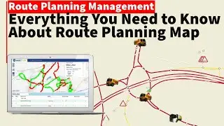
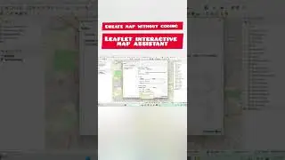
create web GIS map without coding
• QGIS Tutorial: Wep GIS || QGIS || arc...
create free arc ArcGIS online account
• arcgis online. how to create ArcGis ...
create plugin with out coding in QGIS
• QGIS Tutorial : Create A Qgis Plugin ...
how to download OSM data by Area
• QGIS Tutorial : Download OSM Data By ...
..........
-For more information and communication with the admin, you can use the following communication method:
Telegram:
@QAM_12345
Email:
[email protected]
Facebook:
https://www.facebook.com/profile.php?id=10...