Don't Miss This! The Area Between Russia And The Usa Doesn't Have To Be A Big Deal!
The easternmost point in the United States is West Quoddy Head (longitude 66°57′ W). The county is primarily forested with spruce and fir trees, with large stands of maple and beech. Public lands include Moosehorn National Wildlife Refuge; Rocky Lake; and Cobscook Bay, Quoddy Head, and Roque Bluffs state parks
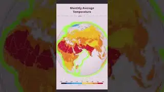
for special analysis more information
click linke below
https://youtube.com/@gem-tech.geo0?fe...
how to create 3D view city buildings
• QGIS Tutorial: Create Impressive 3D City B...
geo spatial analysis with chat gpt
• Geo spatial analysis using ChatGPT - Made ...