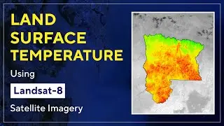
Calculating Land Surface Temperature Using Landsat 8 Imagery In ArcGIS || The GIS Hub ||
The radiative skin temperature of the land that results from solar radiation is known as land surface temperature (LST). The land surface where the incoming solar energy interacts with and warms the ground or the surface of the canopy in vegetated regions is where LST detects the emission of thermal radiation.
In this video, we will learn how to estimate land surface temperature using Landsat 8 imagery in ArcGIS. The data can be downloaded from the USGS website.
How To Download Landsat-8 Satellite Imagery For Free:
• How To Download Landsat-9 Satellite I...
If you want the document in the video, please provide your email in the comment. I will send you in the mail.
------------------------ My Other Videos --------------------------------
Do watch my other videos:
Top 10 GIS Software Applications In 2022
• Top 10 GIS Software Applications In 2...
How To Create A Contour Using DEM Data
• How To Create A Contour Using DEM Dat...
How To Create A Covid-19 Map Using QGIS
• How To Create A Covid-19 Map Using QG...
Supervised Classification Using ArcGIS:
• Supervised Classification Using ArcGI...
How To Create A Map With OSM Data Using QGIS:
• How To Create A Map With OSM Data Usi...
How to Create A Choropleth Map Using Leaflet:
• How To Create A Choropleth Map Using ...
Create A Map Layer Using Leaflet:
• Leaflet JS Tutorial || Create A Map L...
Add A Marker To The Map Layer:
• Leaflet JS Tutorial || Add A Marker T...
Use Different Map Tile Layer In Leaflet:
• Leaflet JS Tutorial || Use Different ...
Add Google Map To Your Website:
• Leaflet JS Tutorial || Add Google Map...
Layer Group And Control In Leaflet:
• Leaflet JS Tutorial || Layer Group An...
Add Shapefile in leaflet:
• Leaflet JS Tutorial || Add Shapefile ...
How to add GeoJSON File in leaflet:
• Leaflet JS Tutorial || Use GeoJSON Wi...
#Landsurfacetemperature #LST #GIS #arcgis #landsat #RemoteSensing #Satellite_Imagery #NASA #Landsat #arcgistutorial #QGIS
Keywords: land surface temperature, LST, GIS, GIS and remote sensing, arcgis tutorial, arcgis, landsat-9, imagery, satellite, qgis, ArcGIS, gis, remote sensing, NASA
Remote sensing, arcgis, GIS youtube channel, geospatial science, LST Calculation, Land surface temperature calculation by Landsat 5 and 7, Calculation of Land surface temperature, LST measurement, Land surface temperature measurement, LST,Landsat 5, Landsat 7, Landsat 8, Land surface temperature calculation, how to calculate Land surface temperature, how to measurement LST, how to measurement Land surface temperature, How to calculate Land surface temperature of Landsat 8 Imagery


![|СОВМЕСТКА| Это любовь в одно касание... [with Ohiko Tyan]](https://images.videosashka.com/watch/inx2Welh5M0)