Add Basemap In QGIS || OSM Basemap, Google BaseMap in QGIS || QGIS Tutorial || The GIS Hub
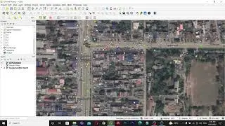
Hello Everyone, In this video, we are going to learn how to add base maps in qgis. There are various types of maps that can be used as base layers in your maps. They might be the OpenStreetMap base layer, Google Map Base layer and Satellite Imagery base layer, and many more.
Do visit my website:
https://www.parajuligaurav.com.np/
----------------------- My Other Videos --------------------------------
Do watch my other videos:
Top 10 GIS Software Applications In 2022
• Top 10 GIS Software Applications In 2...
How To Create A Contour Using DEM Data
• How To Create A Contour Using DEM Dat...
How To Create A Covid-19 Map Using QGIS
• How To Create A Covid-19 Map Using QG...
Supervised Classification Using ArcGIS:
• Supervised Classification Using ArcGI...
How To Create A Map With OSM Data Using QGIS:
• How To Create A Map With OSM Data Usi...
How to Create A Choropleth Map Using Leaflet:
• How To Create A Choropleth Map Using ...
Create A Map Layer Using Leaflet:
• Leaflet JS Tutorial || Create A Map L...
Add A Marker To The Map Layer:
• Leaflet JS Tutorial || Add A Marker T...
Use Different Map Tile Layer In Leaflet:
• Leaflet JS Tutorial || Use Different ...
Add Google Map To Your Website:
• Leaflet JS Tutorial || Add Google Map...
Layer Group And Control In Leaflet:
• Leaflet JS Tutorial || Layer Group An...
Add Shapefile in leaflet:
• Leaflet JS Tutorial || Add Shapefile ...
How to add GeoJSON File in leaflet:
• Leaflet JS Tutorial || Use GeoJSON Wi...
Keywords:
OpenStreetMap, OSM Data, Google, Satellite, Imagery, Satellite Imagery, Google Satellite, Google Map, Add OSM Base Layer, QGIS, QGIS Tutorials,
qgis, qgis tutorial, qgis add basemaps, qgis add map tiles, qgis maps,add maps to qgis, qgis import maps, qgis openlayers plugin, qgis quickmapservices, qgis qms, qgis openstreetmap, maps for qgis, qgis google maps, google maps qgis, qgis bing maps, bing maps qgis, adding satellite image in qgis, satellite image in qgis, openlayers plugin in qgis, satellite imagery, add satellite imagery to arcmap, qgis and google satellite, adding satellite image, openlayers plugin, satellite, google satellite, qgis 3.0 google imagery,gis software, google map, qgis and google map,remote sensing, qgis, gis,google earth, arcgis, maps,google maps, google, earth, street view, google street view, google earth secrets, openlayers, georeferencing, mapping, plugin