How to Join Attribute Data From Excel to Shapefile in QGIS | Joining CSV or Spreadsheet Attributes
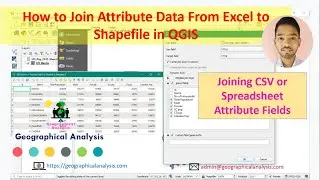
Hi friends, in this video we will learn about 'The procedure of Join Attribute data to shapefile in QGIS software from excel'. In this video, we will use CSV and Spreadsheet data.
We try to solve your queries regarding:
how to join excel data to shapefile in qgis
how to Attribute data from excel in qgis
how to add csv data in qgis
Procedure:
00:18 - Join Attribute Data Using CSV File in QGIS
08:01 - Join Attribute Data Using Excel Spreadsheet File in QGIS
"LULC and Change Detection Series" Playlist: • Landuse and Landcover Classification ...
**Remote Sensing and GIS Book - https://amzn.to/3h2PIxY
**MY MIC - https://amzn.to/2SBfobs
**MY LAPTOP - https://amzn.to/3dvlxND
**HP Ink Tank Printer - https://amzn.to/3y85Io6
**MY Keyboard and Mouse - https://amzn.to/3y3jS9K
**Bluetooth Headphone - https://amzn.to/3629UcR
Previous Videos:
Land Use and Land Cover Supervised classification in QGIS | Semi-Automatic Classification
• Land Use and Land Cover Supervised cl...
Landsat 8 Image Preprocessing in QGIS | Atmospheric Correction | LULC and Change Detection Series
• Landsat 8 Image Preprocessing in QGIS...
Download LISS_III Satellite Images From Bhuvan.nrsc.gov.in || Bhuvan Satellite Images Download
• Download LISS III Satellite Images Fr...
Georeference a Map with Google Maps, Wikimedia Maps, Bing Maps etc. in QGIS using OpenLayers Plugin
• Georeference a Map with Google Maps, ...
How to Georeference a Map with another Georeferenced Map
• How to Georeference a Map with anothe...
How to Georeference in QGIS | Georeference a map with Latitude and Longitude
• How to Georeference in QGIS | Georefe...
Creating Map Layouts in QGIS | QGIS Print Composer - Printing and Exporting
• Creating Map Layouts in QGIS | QGIS P...
Calculate NDVI using QGIS || NDVI in QGIS 3.4
• Calculate NDVI using QGIS || NDVI in ...
Download Landsat 8 Satellite Images From earthexplorer.usgs.gov
• Download 'Landsat 8' Satellite Images...
Solve all Plugins Install Problems on QGIS || OpenLayers plugin qgis 3.4
• Solve all Plugins Install Problems on...
QGIS Software Basic Settings and Toolbars (Version 3.4)
• QGIS Software Basic Settings and Tool...
How to install QGIS Software 3.4 Madeira in Bengali
• How to install QGIS Software 3.4 Made...
ALL tutorials will be uploaded one by one.
Install QGIS (3.4 Madeira)
Understanding Various Tools
Free Satellite Imagery Data Sources
Know About Various Plugin and Install
Use Google Earth in QGIS
Georeferencing
Link Excel Data on QGIS
Land Cover Classification
Supervised classification by QGIS
Semi-Automatic Classification Plugin on QGIS
Making Various Maps ( Choropleth, Pie, Histogram, DEM, Contour, 3D maps, etc.)
Creating Map Layouts in QGIS
QGIS Print Composer
So stay updated...
Like our Youtube Channel for the next update and videos.
/ @geographicalanalysis
For any queries
E-mail
[email protected]
Follow on
Facebook Page
/ geographicalanalysis
Twitter
/ geographicala
Website:
https://geographicalanalysis.com
#Join_Excel_Data #Join_Attribute_Data #QGIS


