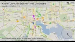
Charm City Circulator Real-Time Data Movements with Google Maps Traffic Layer
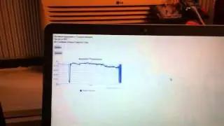
This animation shows movements of the Charm City Circulator bus fleet in Baltimore, MD on Saturday, April 7th, 2013. The Bus movements were pulled every 15 seconds using the Circulator's nextBus Real-time API. Screenshots of the Google Maps Traffic Layer were pulled every 45 seconds, to show the effects of heavy traffic on the spacing and speed of buses.
For all of you non-Baltimoreans, the Charm City Circulator is a city-run bus system (completely separate from the state-run MTA) that serves Baltimore's downtown and adjacent neighborhoods. It has no schedule, and instead tries to maintain short headways. It has no confusing route numbers, and consists of user-friendly color-coded routes. The vehicles are hybrid electric, and the system boasts many high-tech features such as arrival time signs at high-traffic stops, an official app, and the real-time XML API that made this visualization possible.
Made at Betamore during the Reinvent Transit Hackathon, 5-7 April 2013. Made with Processing (Processing.org)
Code available on github(link coming soon)
Made in Baltimore by @chris_whong, @chasegilliam, and Brian Mackintosh
Attribution:
"GeoTrails" by Dave Troy:
github.com/davetroy/GeoTrails/blob/master/GeoT
rails.pde