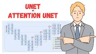
Take Your Tensorflow Skills to New Heights with Attention Unet
Attention, in the context of image segmentation, is a way to highlight only the relevant activations during training. This reduces the computational resources wasted on irrelevant activations, providing the network with better generalisation power. Essentially, the network can pay “attention” to certain parts of the image.
Paper: https://arxiv.org/abs/1804.03999
#unet #imagesegmentation #deeplearning
Timestamps:
0:00 Intro
1:23 Type of attentions (soft and hard)
2:34 Unet vs Attention Unet
5:04 Attention Unet Workflow
8:43 Attention Unet Implementation in Tensorflow (Keras)
----------------------------------------------------------------------------------------
Here are some playlists that you might be interested in:
----------------------------------------------------------------------------------------
End to End deep learning using GEE dataset: • End to End Deep Learning | From data ...
Deep Learning for Satellite Imagery: • Deep learning for satellite imagery |...
Machine learning from the basic: • Machine Learning for geospatial data
Historical Imagery Processing: • Historical Imagery processing | KH-9 ...
Leaflet from basic to advance: • Leaflet from basic to advance
GeoServer with leaflet web-GIS: • GeoServer and Leaflet Web-GIS
GeoDjango project: • Bookmark note on map | GeoDjango tuto...
geoserver-rest: • geoserver-rest
GIS training in Nepali: • Beginner GIS training in Nepali | Arc...
LULC map production: • LandUse Land Cover Map production || ...
Geospatial analysis with python: • GeoSpatial analysis with python
GeoNode from basic to advance: • GeoNode from basic to Advance
--------------------------------------------------------------------------------------------------------------
Check out my discounted courses at the following link:
--------------------------------------------------------------------------------------------------------------
1. "Geospatial data analysis with python": https://www.udemy.com/course/geospati...
2. "Web GIS Development 2021": https://www.udemy.com/course/web-gis-...
3. "Web mapping and Web-GIS from Dev to Deploy 2021: GeoDjango": https://www.udemy.com/course/web-mapp...
4. "Introduction to Web Mapping and Web GIS 2020: GeoDjango": https://www.udemy.com/course/introduc...
5. Deep Learning Application for Earth Observation: https://www.udemy.com/course/deep-lea...
6. Geospatial Data Analysis with Python: https://www.udemy.com/course/geospati...
---------------------------------------------------------------------------------------------------
Follow me on GitHub: https://github.com/iamtekson
Follow me on Twitter: / iamtekson
Follow me on Instagram: / iamtekson
Join Facebook group: / 1049524025731229
-----------------------------------------------------------------------------------------------------