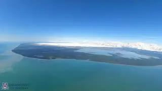
Malaspina glacier fly-over
This video captures a Cessna 206 flight over Sít’ Tlein (Malaspina Glacier) on May 31st, 2022, following a repeat lidar survey of the coastal land in front of the glacier. The forested land that separates the world's largest piedmont glacier from the Gulf of Alaska contains buried ice below the surface and is actively thinning and wasting away, creating pathways for ocean water intrusion to the glacier's front margin. In addition to airborne lidar surveys aimed at measuring changes in the surface height, NASA Operation IceBridge mapped the glacier's bed in detail with airborne radio echo sounding. This video clip covers a flight distance of nearly 100 km, which took around 30 minutes to fly in real-time. The video ends shortly after passing Mount Saint Elias, which rises to 5.5 km (18,008 ft) just onshore from Icy Bay.
The related AGU journal paper:
Comprehensive Radar Mapping of Malaspina Glacier (Sít' Tlein), Alaska—The World's Largest Piedmont Glacier—Reveals Potential for Instability
JGR Earth Surface [2023]
B. S. Tober, J. W. Holt, M. S. Christoffersen, M. Truffer, C. F. Larsen, D. J. Brinkerhoff, S. A. Mooneyham
https://agupubs.onlinelibrary.wiley.c...
UA press release: https://news.arizona.edu/story/3d-rad...
Video courtesy of Brandon Tober. Used here with permission.
Editing by Larry O'Hanlon