12 тысяч подписчиков
181 видео
How to make a 3D model in QGIS using the QGIS2threejs extension
How to convert from WGS84 XY Lat Long coordinate system using on line convertor tool.
ENVI Tutorial For begginers Part 1 l ENVI Interface
How to remove cloud and cloud shadow from Satellite images using ArcGIS/Pro
How to download Copernicus DSM/DEM and NASA DEM from OpenTopography
how to download and add grammarly in word easy step
Surface Water Mapping using GEE | Modified Normalized Difference Water Index (MNDWI)
How to create shapefile and Digitize in ArcGIS Pro
Google earth engine | how to import the Shapefile, Table and Raster images into GEE
Outlier Analysis in ArcGIS | Pattern detection and statistical analysis
How to measure the distance to Nearest Location using Point distance in ArcMap | proximity | Nearest
Advanced QGIS2 Tutorial 2 || Spatial Join and Summary Statistics
How to re project Raster Dateset in ArcMap Convert Reference system From WGS 84 to UTM adindan 37
How to get LANDSAT Path and Row grid | Download the LANDSAT Path and Row grid
HOW TO GEOCODE POINTS USING AECGIS PRO
HOW TO CONVERT FROM NetCDF FILE FORMAT TO RASTER LAYER | ArcGIS Pro
Flood Prone area delineation using GIS and AHP method= Part 2
How to composite || clip || remove clouds || from Landsat image in Google Earth Engine.
How to access Global Human Settlement Layers, Settlement Grid 1975-1990-2000-2014 using GEE
Accuracy Assessment of classified image using ArcGIS Pro Tutorial P2
13 Open Source Remote Sensing Software Packages
3D PROXIMITY Analysis in ArcGIS Pro
Advanced QGIS | Hpw to Query using Extract by expression
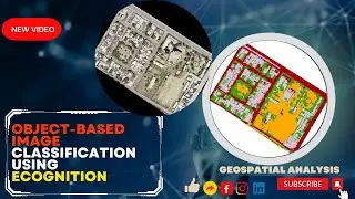
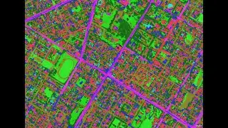
Mastering Object-Based Image Classification with eCognition | Step-by-Step
How to download high resolution Georeferenced Google Earth Imagery using QGIS for free?
Image classification in ArcGIS Pro step by step on how to create new schema and training samples.
How to select Multiple Features in the Attribute table
How to create 3D topographic map in Qgis
How download SPOT IMAGE for free
labeling in Qgis
How to add Basemap or Openstreat map in QGIS QGISplugin
How to create annd validate ArcGIS Geodatabase Topology || Spatial Data Integerity
HOTSPOT ANALYSIS | Spatial Data Science In ArcGIS PRO
How to prepare interactive Map Layout in QGIS
How to solve Invalid Topology using Repair Geometry tool if your clip is not working
Random Tree clasifier in arcmap I machien learning I deep learning classification
Object based image classification in
How to use model builder in ArcMap. Drainage Density computation using Model Builder in ArcMap
Download Open Data from OSM Geofabrik using QGIS HCMGIS | Builddings | Roads
How to download Annual rainfall data using Google Earth Engine GEE
How to Visualize GPS tarck using QGIS create an animated GIF showing the trip
How to convert from netCDF data to Raster format
Orthorectifying Satellite Imagery Using ArcGIS || How can you make an image map-accurate?
How to calculate engine vector in IDRIS software for criteria weighting for weighted overlay ArcMap
how to Resample in ArcMap. resampling in ArcMap
How to classify satellite image using ArcGIS Pro P1
3D MAPPING in ARCGIS PRO
How to Clip multiple layers to a polygon in QGIS using Batch Processing
How to convert fro 16bit GeoTiff image to 8bit image
extract X,Y and Z value of points from DEM in ArcMap