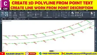
Profile from Center Line XYZ Data | Profile from File | Export Feature Lines Station Including XYZ
Profile from Center Line XYZ Data
Profile from File
Export Feature Lines with Station including XYZ
In this tutorial, the process of creating profiles from center line XYZ data. It begins with importing point data and setting up the station, followed by the creation of the profile while aligning the line. The video also covers the conversion of center line data into feature lines for profile generation, along with a comprehensive check and analysis of the data before conversion. Furthermore, it demonstrates the generation and export of feature lines from XYZ data, undergoing elevation interpolation for parallel alignment. Importantly, it illustrates the conversion of underground data into feature lines as well as the process of converting 3D polylines into feature lines, with a focus on selecting the alignment. The final steps involve exporting the feature lines, including XYZ data, and the file, which encapsulates the station line and elevation values in NSL. The video thoroughly delves into the process involved in formatting and copying the values, ending with the export of feature lines station and XYZ data, accompanied by the creation of a report and the export of data to Excel.
Share your thoughts on this efficient process or explore further by watching the complete video tutorial.
Creating Feature Lines and Exporting Data for Profile Generation | Naseer Bhatti
Creating profile from center line XYZ data
• The process involves bringing point data and setting its station.
• Then creating the profile using the given data and aligning the line.
Converting center line data into feature line for profile creation.
• Checking and analyzing the data before conversion.
• Showing the exported data and identifying potential issues.
Creating feature lines from XYZ data and exporting them
• Elevations are interpolated to create parallel alignment
• Converting underground data into feature lines and exporting
Converting 3D polyline to a feature line
• Selecting the alignment for the feature line
• Exporting the feature line including XYZ data
Exported file includes station line and elevation value
• The file includes station elevation value in NSS
• Process involved in formatting and copying the values
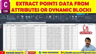
Export Feature Lines Station and XYZ Data
• The video demonstrates how to export feature lines station including XYZ data.
• It shows the process of creating a report and exporting data to Excel.
Creating a profile from XYZ data in the file
• Importing files and setting up the folder location
• Step by step process of creating a profile
Creating and naming profiles in the file
• Creating a profile in the file using profile property NSLT and another one
• Highlighting the difference between two levels in the profile
Link for Country kit
https://www.autodesk.com/support/tech...
Timecodes
0:00 creating profile from center line XYZ data
3:21 converting center line data into feature line for profile creation.
6:42 creating feature lines from XYZ data and exporting them
7:57 converting 3D polyline to a feature line
10:17 Exported file includes station line and elevation value
11:27 Export Feature Lines Station and XYZ Data
14:19 creating a profile from XYZ data in the file
16:58 Creating and naming profiles in the file


![[FREE] Freestyle Type Beat -](https://images.videosashka.com/watch/vFyL4lyCBio)