Filtering Point Cloud using CloudCompare | LAND4 for ARCHICAD®
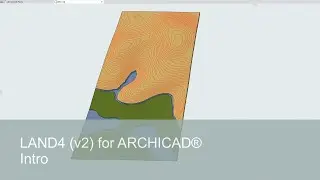
From Point Cloud to flexible terrain model (LANDSurface) in ARCHICAD. This video shows how to handle, filter and classify a Point Cloud using CloudCompare* before importing the Point Cloud into ARCHICAD using LAND4.
You will be guided through the process of cleaning up, preparing for import, and importing a Point Cloud:
removing noise (using outlier removal)
sub-sampling (spacing)
classifying points (ground/off-ground).
importing into ARCHICAD.
showing points as LAND4 Spot Levels.
creating a terrain model (a LANDSurface) from the LAND4 Spot Levels.
If you use (LIDAR, drone, laser scanning) raw data, this process will be essential when it comes to optimizing the size/quantity and the quality of your Point Cloud, before importing it into ARCHICAD using LAND4.
-----------------------------------------------
CloudCompare is a third-party, open source software. For more information, go to https://cloudcompare.org/